Vancouver, British Columbia--(Newsfile Corp. - November 12, 2026) - Sun Summit Minerals Corp. (TSXV: SMN) (OTCQB: SMREF) ("Sun Summit" or the "Company") is pleased to announce results from the summer 2026 exploration program on the Buck Project, central British Columbia. The program focused on the western side of the project area, centered on the CR Porphyry Trend.
Highlights:
New DCIP data enhances the CR Porphyry Trend: The new DCIP data together with compiled data from previous surveys highlight strong geophysical anomalies locally associated with zones of porphyry-related copper-molybdenum mineralization.
Compilation highlights untested porphyry targets: Multiple coincident chargeability, magnetic, and multi-element soil geochemical anomalies are identified across the interpreted 12 km trend. Only two targets have been previously drill tested.
Planning underway for future exploration program: The largely drift-covered and concealed CR Porphyry Trend will be the focus for further DCIP and soil geochemical surveys aimed at refining drill targets.
"While our primary focus remains on our flagship JD Property in the Toodoggone Mining District, we allocated a modest budget at our 100% owned Buck Project in central BC. The filed expenditures have pushed out the anniversary date for the CR claims to the year 2030," stated Niel Marotta, CEO of Sun Summit Minerals. "The CR Porphyry trend, on the western side of the Buck Project, hosts multiple near-surface porphyry targets that offer discovery and expansion potential. The project is road-accessible and benefits from excellent infrastructure, sitting just south of Houston, BC. Central British Columbia remains a premier jurisdiction for porphyry and epithermal exploration, as demonstrated by the strong regional activity from peers like Amarc, Vizsla Copper, Surge Copper, Equity Metals, and American Eagle."
2026 CR Exploration Program
The 2026 exploration program at the Buck project, 10 km south of Houston, BC focused on the CR Porphyry Trend - a 12 kilometer north-south corridor of porphyry-related copper-molybdenum targets on the western side of the project area (Figure 1). The program was designed to evaluate the exploration potential of the trend through integration of historical exploration data with newly acquired geochemistry and DCIP (direct current induced polarization) geophysical data.
The 2026 program expanded the geochemical database through collection of 430 soil samples, 26 rock samples and 13 stream sediment samples and included a statistical evaluation of 2026 geochemical datasets. The purpose of the work was to evaluate the exploration potential of the western side of the property through integration of historical exploration data, recent geological mapping, rock sampling, stream sediment sampling, soil geochemistry and interpretation of newly collected exploration geochemistry.
Soil samples were collected on an east-west oriented grid with 100 m sample spacing and 200 m line spacing. Silt samples were collected opportunistically where east-west oriented sampling grid lines intersected streams containing suitable fine-grained sediment accumulations. Rock samples were collected opportunistically where east-west oriented survey lines intersected outcrop.
The 2026 grid-based, DCIP survey focused on the CR South porphyry target and consisted of 8.8 line-kilometres across 4 north-south oriented lines spaced 400 metres apart (Figure 1a). The survey was designed to characterize and detect sulfide mineralization east of an open-ended high-chargeability anomaly defined in the historic data and associated with known porphyry-related copper-molybdenum mineralization (Figure 1a and 1b).
Data from the 2026 DCIP survey has been compiled with results from over 61-line kilometres of historic IP data collected between 1994 and 2019. The compilation model covers only 8.0 kilometres of the CR Porphyry Trend and defines three broad chargeability anomalies (Figure 1). Highlights include:
CR South: The DCIP compilation defines a strong, >20mV/V chargeability anomaly, that covers approximately 1.7 by 0.7 kilometres and is spatially coincident with an elliptical magnetic anomaly (e.g., magnetic low within a circular magnetic-high). These coincident geophysical anomalies are also coincident with broad zones of elevated copper in potassic altered rock samples (up to 1.3% Cu1) and consistent high copper-in-soil geochemistry (Figure 1a and 1b). Mineralization occurs within an east-west oriented corridor, hosted primarily in granodiorite, hydrothermal breccia and quartz-feldspar porphyries. The CR South target has been investigated by 15 shallow drill holes totaling 3,570 metres primarily in 2005 and 2007. Significant drill intercepts include 68.0 metres at 0.50% Cu and 0.015% Mo in drill hole CR05-031; and 168.0 metres at 0.37% Cu and 0.017% Mo in drill hole CR07-143. Copper-molybdenum mineralization consists of quartz-chalcopyrite-molybdenite+/-bornite veins and stockwork zones and as hydrothermal cement (chalcopyrite-biotite-magnetite) within brecciated granodiorite. Results from the 2026 DCIP survey are interpreted to indicate potential for additional porphyry-related mineralization at depth and to the east of previous drilling (Figure 1b).
CR North: The dominantly till-covered CR North porphyry target is centered approximately 1.8 kilometres north of the CR South porphyry target. Sparse outcrop comprises mostly andesite cut by local granodiorite and QFP dykes with variable propylitic and phyllic alteration. A broad and open zone of sulfide-cemented breccia has been observed near the southern extent of the target. The target area consists of a broad 1.2 by 0.6 kilometer copper-in-soil anomaly on the margins of a strong magnetic high anomaly, coincident with the southern extent of the broad ~2.7 by 1.0 km, >20 mV/V high-chargeability anomaly (Figure 1a). Most of the chargeability anomaly is associated with a broad magnetic-low anomaly interpreted to represent zones of hydrothermal alteration. This broad target area has only been evaluated by 2 previous drill holes totalling 876.5 metres by Teck Resources in 2019. Both holes intersected zones of hydrothermal alteration with local intervals of porphyry-related copper mineralization (e.g., 4.1 metres at 1.05% Cu and 18.1 metres at 0.18% Cu in drill hole CR19-021) associated with propylitic and local k-feldspar-biotite alteration. Further exploration and drilling is warranted across the broad and highly prospective target area.
CR Far North and CR Far South: Two additional targets are defined based on geophysical data on the northern and southern extent of the CR Porphyry Trend (Figures 1a and 2). The CR Far North target consists of a broad moderate high-chargeability anomaly coincident with a magnetic-high anomaly. The CR Far South target represents a discrete magnetic-high anomaly along trend from the CR South porphyry system. The magnetic-high anomaly is interpreted to represent a concealed magnetic intrusion, similar to the margins of the CR South and CR North porphyry targets (Figure 2). Both targets lack soil geochemical coverage and the CR Far South target lacks IP coverage.
The CR Porphyry Trend is interpreted to be underlain by a package of andesite, rhyolite and associated volcaniclastic rocks of the Lower to Middle Jurassic Telkwa Formation of the Hazelton Group. These volcanic rocks are cut by prospective quartz-feldspar porphyry intrusions, granodiorite dykes and feldspar-porphyritic andesite locally associated with porphyry-related copper-molybdenum mineralization.
Next Steps
Planning is underway for future exploration across the CR Porphyry Trend and includes compilation of all new data and interpretation and drill target prioritisation.
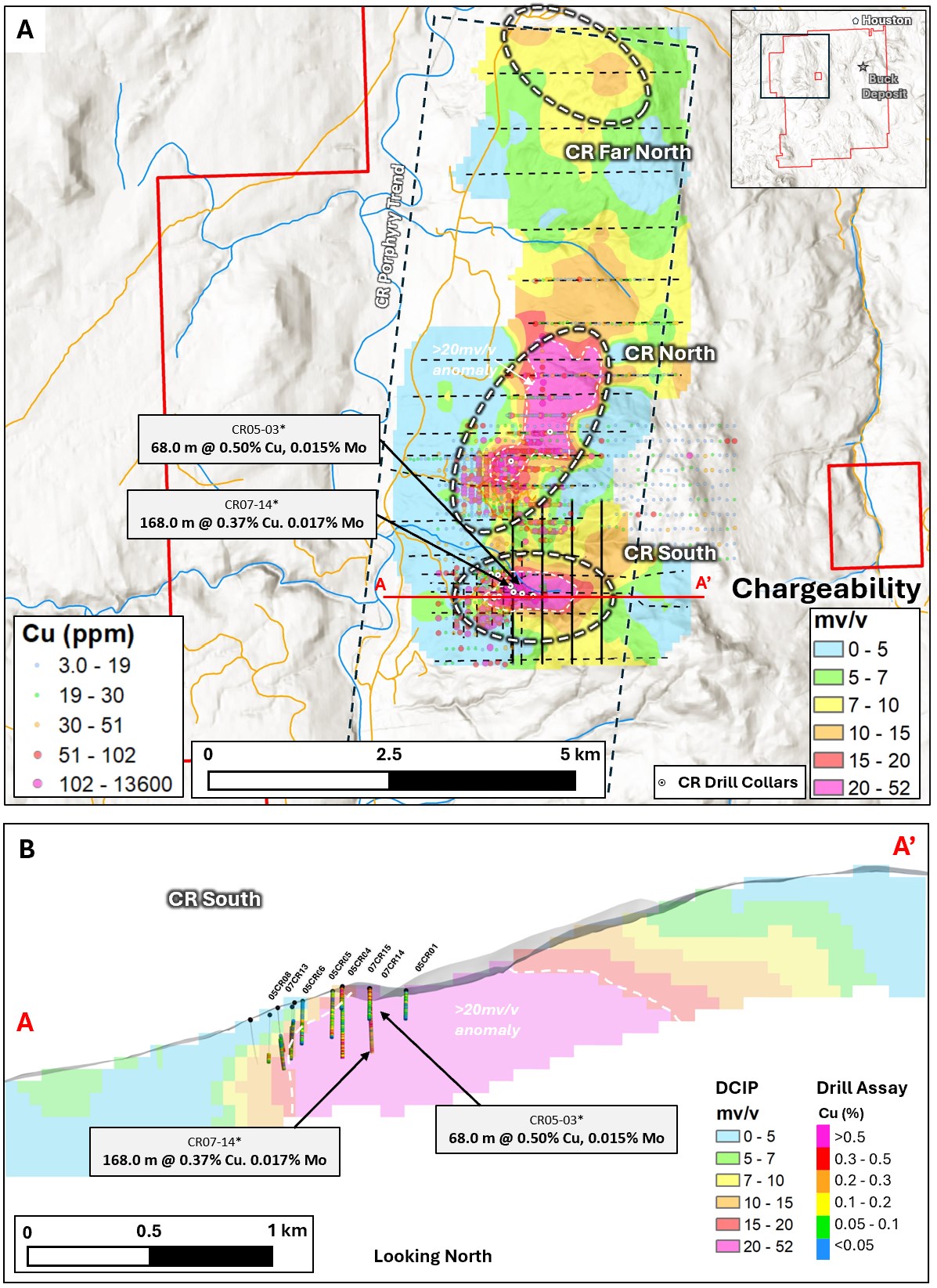
Figure 1. CR Porphyry Trend, A. Map of the Buck project showing the recently compiled IP data (125 metre depth slice through the chargeability model) across the CR Porphyry trend. New (black) and historical DCIP lines (dashed) are shown. Key targets are highlighted together with compiled soil geochemical data showing copper. Section line (A-A') for Figure 1b is shown, B. Section through the 3D voxel model showing the strong chargeability anomaly at CR South (A-A') in relation to historical drilling. Note, only a small portion of the chargeability anomaly has been evaluated with drilling. See references below for sources of historical DCIP, soil geochemical and drill data.
To view an enhanced version of this graphic, please visit:
https://images.newsfilecorp.com/files/6142/323533_3510c09264070aae_002full.jpg
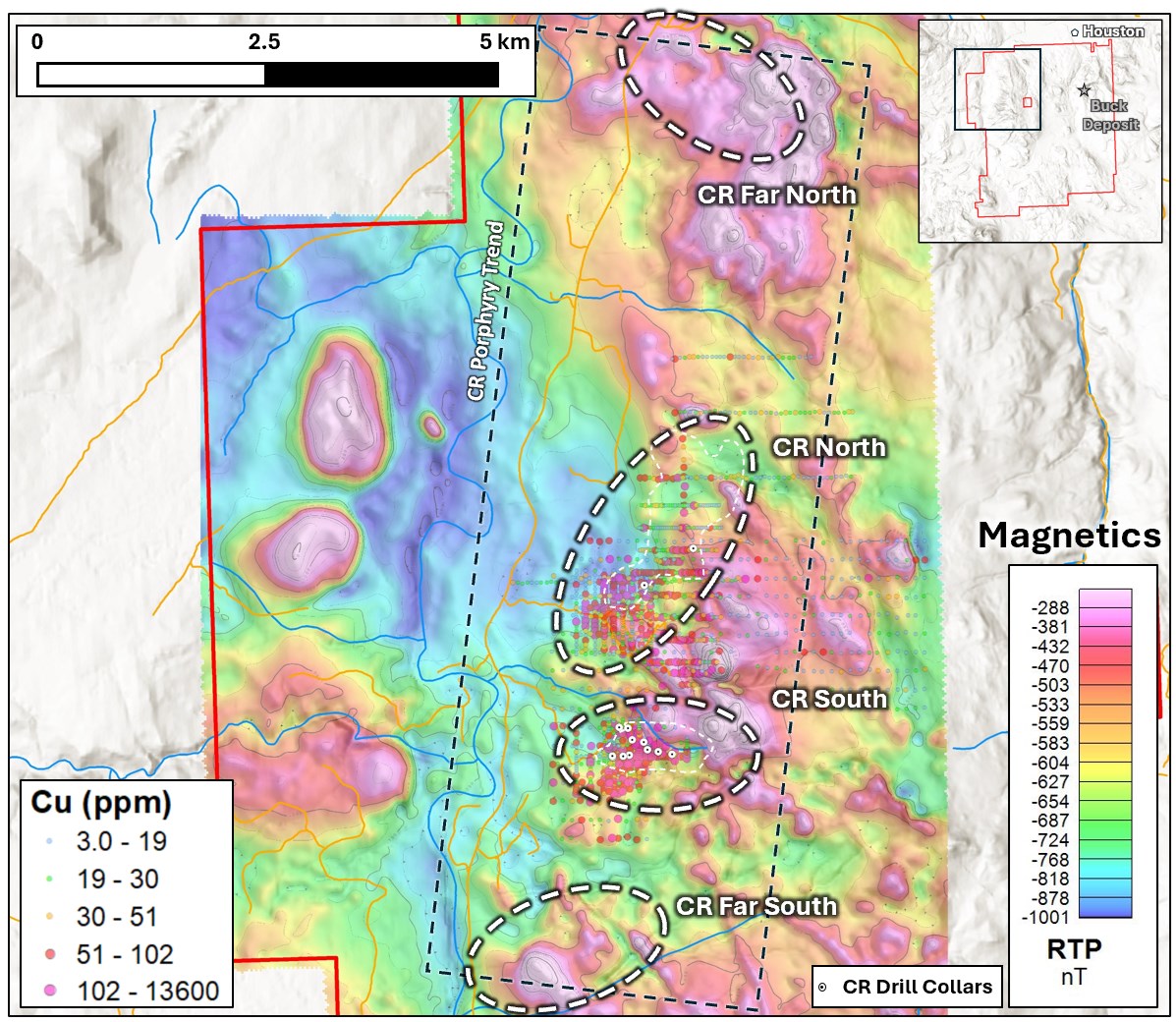
Figure 2. CR Porphyry Trend showing magnetic data from a 2018 survey in relation to copper-in-soil geochemistry and the location of key target area. See references below for sources of historical geophysical and geochemical data.
To view an enhanced version of this graphic, please visit:
https://images.newsfilecorp.com/files/6142/323533_3510c09264070aae_003full.jpg
Quality Assurance and Quality Control
Samples were placed in rice bags and security tags were affixed to each rice bag to maintain sample security and chain of custody. Samples were subsequently shipped to ALS Canada Ltd. in North Vancouver, via Bandstra Transportation Systems, for geochemical analysis. ALS Global is registered to ISO/IEC 17025:2017 accreditations for laboratory procedures.
Soil and silt samples were prepared and analyzed at ALS Canada Ltd. in North Vancouver. The soil samples were dried at <60°C and then sieved to -180 micron (80 mesh) in preparation for analysis. A 25g split was weighed out from the sieved sample and then analyzed using the AuME-TL43 package. This package is a multi-element (51 elements) trace level method using aqua regia digestion and analyzed by an ICP-MS finish. ALS is independent of the Company.
Rock samples were prepared and analyzed at ALS Canada Ltd. in North Vancouver. The rock samples were finely crushed to a target of 70% passing 2 mm. Then the sample was passed through a riffle splitter and up to 250 g was pulverized to a target of 85% passing 75 microns. Rock samples were then analyzed with the trace-level analytical packages Au-AA23 and ME-MS61. The Au-AA23 package analyzes Au by 30 g lead fire assay and atomic absorption spectroscopy (AAS). The remaining elements were analyzed with multi-element (48 elements) package ME-MS61 that uses a 4-acid digestion and ICP-MS finish.
National Instrument 43-101 Disclosure
This news release has been reviewed and approved by Sun Summit's Vice President Exploration, Ken MacDonald, P. Geo., a "Qualified Person" as defined in National Instrument 43-101 Standards of Disclosure for Mineral Projects of the Canadian Securities Administrators. Mr. MacDonald has verified the data disclosed in this press release, including the sampling, analytical and test data underlying this information that has been collected by Sun Summit. Verification procedures include industry standard quality control practices. Some technical information contained in this news release is historical in nature and has been compiled from public sources believed to be accurate. The historical technical information has not been verified by Sun Summit and may in some instances be unverifiable dependent on the existence of historical drill core and grab samples.
Community Engagement
Sun Summit is engaging with First Nations on whose territory our projects are located and is discussing their interests and identifying contract and work opportunities, as well as opportunities to support community initiatives. The Company looks forward to continuing to work with local and regional First Nations with ongoing exploration.
About the Buck Project
The Buck Property consists of 62 mineral claims covering approximately 53,638 ha and is located approximately 10 km south of Houston, British Columbia, within the Omineca Mining Division. The property is readily accessible from Highway 16 via Morice River Road and Buck Flats Road and a network of forestry and exploration roads. The Buck Project is situated in a historic mining district with excellent nearby infrastructure that allows for year-round, road-accessible exploration. Mineralization on nearby properties is not necessarily indivative of mineralization on the Buck Project.
The property is situated within the Stikine Terrane and is underlain by a diverse assemblage of volcanic, volcaniclastic, sedimentary and intrusive rocks including Hazelton Group volcanic rocks, Skeena Group sedimentary rocks, Kasalka Group volcanic rocks and related intrusive phases. Regional deformation is characterized by northwest-trending faults that provide favourable pathways for hydrothermal fluid flow and mineralization.
The project is host to the Buck Main intermediate-sulfidation epithermal-related gold-silver-zinc system. Most of the mineralization drilled to date at Buck Main consists of long, continuous zones of disseminated and breccia-hosted, bulk tonnage-style gold-silver-zinc. Vein-hosted, high-grade mineralization has also been intersected near the center of Buck Main.
Exploration at the Buck Project is focused on investigating the lateral and vertical extent of gold-silver-zinc mineralization at the Buck Main system, and to define additional drill targets across the entire land package through systematic exploration programs.
About the JD Project
The JD Project is located in the Toodoggone mining district in north-central British Columbia, a highly prospective deposit-rich mineral trend. The JD Project covers an area of over 15,000 hectares and is in close proximity to active exploration and development projects, such as Thesis Gold and Silver Inc.'s Lawyers and Ranch projects, TDG Gold Corp's Baker-Shasta projects, Amarc Resource Ltd.'s AuRORA project, Centerra Gold Inc's Kemess East and Underground projects, as well as the past-producing Kemess open pit copper-gold mine.
The project is 450 kilometres northwest of the city of Prince George, and 25 kilometres north of the Sturdee airstrip. It is proximal to existing infrastructure in place to support the past-producing Kemess mine, including roads and a hydroelectric power line.
The JD Project is in a favourable geological environment characterized by both high-grade epithermal gold and silver mineralization, as well as porphyry-related copper and gold mineralization. Some historical exploration, including drilling, geochemistry and geophysics, has been carried out on the property, however the project area is largely underexplored.
About Sun Summit
Sun Summit Minerals (TSXV: SMN) (OTCQB: SMREF) is a mineral exploration company focused on the discovery, expansion, and advancement of district-scale gold and copper assets in British Columbia. The Company's portfolio is anchored by its flagship JD Project, alongside the Theory and Orbit Projects in the prolific Toodoggone region of north-central BC, and the Buck Project in central B.C.
Further details are available at www.sunsummitminerals.com.
References
1 2026 Geological Assessment Report on the CR Zone of the Buck Property, BC Ministry of Energy and Mines, AR TBD, 296 p
2 Kraft et al, 2019, Year-End Report on Geophysical, Geological and Geochemical Work Conducted During 2019, CR Mineral Tenure, Omineca Mining Division, BC Ministry of Energy and Mines, AR 39054, 352 p
Link to Figures
On behalf of the board of directors
Niel Marotta
Chief Executive Officer & Director
info@sunsummitminerals.com
For further information, contact:
Matthew Benedetto, Simone Capital
mbenedetto@simonecapital.ca
Tel. 416-817-1226
Forward-Looking Information
Statements contained in this news release that are not historical facts may be forward-looking statements, which involve risks, uncertainties and other factors that could cause actual results to differ materially from those expressed or implied by such forward-looking statements. In addition, the forward-looking statements require management to make assumptions and are subject to inherent risks and uncertainties. There is significant risk that the forward-looking statements will not prove to be accurate, that the management's assumptions may not be correct and that actual results may differ materially from such forward-looking statements. Accordingly, readers should not place undue reliance on the forward-looking statements. Generally forward-looking statements can be identified by the use of terminology such as "anticipate", "will", "expect", "may", "continue", "could", "estimate", "forecast", "plan", "potential" and similar expressions. Forward-looking statements contained in this press release may include, but are not limited to, the timing of and size and scope of the drill program at the JD Project; the Company's expectation that results from the 2026 drill program will contribute to an inaugural mineral resource estimate and the timing of any such estimate; the advancement of exploration targets at the JD Project; the anticipated completion, interpretation and utilization of geophysical, geological, geochemical and geochronological studies, including MobileMT and potential IP surveys; and the Company's exploration plans, expectations and forecasts. These forward-looking statements are based on a number of assumptions which may prove to be incorrect which, without limiting the generality of the following, include: the Company's ability to complete the drill program as currently contemplated; risks inherent in exploration activities; volatility and sensitivity to market prices; volatility and sensitivity to capital market fluctuations; and fluctuations in metal prices. The forward-looking statements contained in this news release are made as of the date hereof or the dates specifically referenced in this press release, where applicable. Except as required by applicable securities laws and regulation, Sun Summit disclaims any intention or obligation to update or revise any forward-looking statement, whether as a result of new information, future events or otherwise, except as required by applicable securities laws. All forward-looking statements contained in this press release are expressly qualified by this cautionary statement.
Neither the TSX Venture Exchange nor its Regulation Services Provider (as that term is defined in the policies of the TSX Venture Exchange) accepts responsibility for the adequacy or accuracy of this release.

To view the source version of this press release, please visit https://www.newsfilecorp.com/release/323533